Country Feature – The Democratic Republic of Timor-Leste (Timor-Leste)
COUNTRY FEATURE
DEMOCRATIC REPUBLIC OF TIMOR-LESTE
(TIMOR-LESTE)
 Image 1: Dolok Oan Beach, Dili
FACTS ABOUT TIMOR-LESTE
Capital – Dili
Location – between the Southeast Asia and South Pacific
Territory – 15,007 square kilometres
Population – 1,340,434 million people (Population & Housing Census 2022)
Language –Tetun & Portuguese (Official Languages), English & Bahasa Indonesia (Working Languages)
Currency – USD and Centavos
Religion: The main religion is Roman Catholic. There are also small communities of Protestants, Muslims, Kong Hu Cuism and Hindus
Most populated municipalities: Dili, Baucau, Ermera, Bobonaro
National holiday: 20 May – Restoration of Independence Day, and 28 November – Proclamation of Independence
Natural resources: Oil and gas, minerals and agriculture produce such as coffee
State borders – Timor-Leste has only two immediate neighbours: Indonesia (land border) and Australia (maritime border)
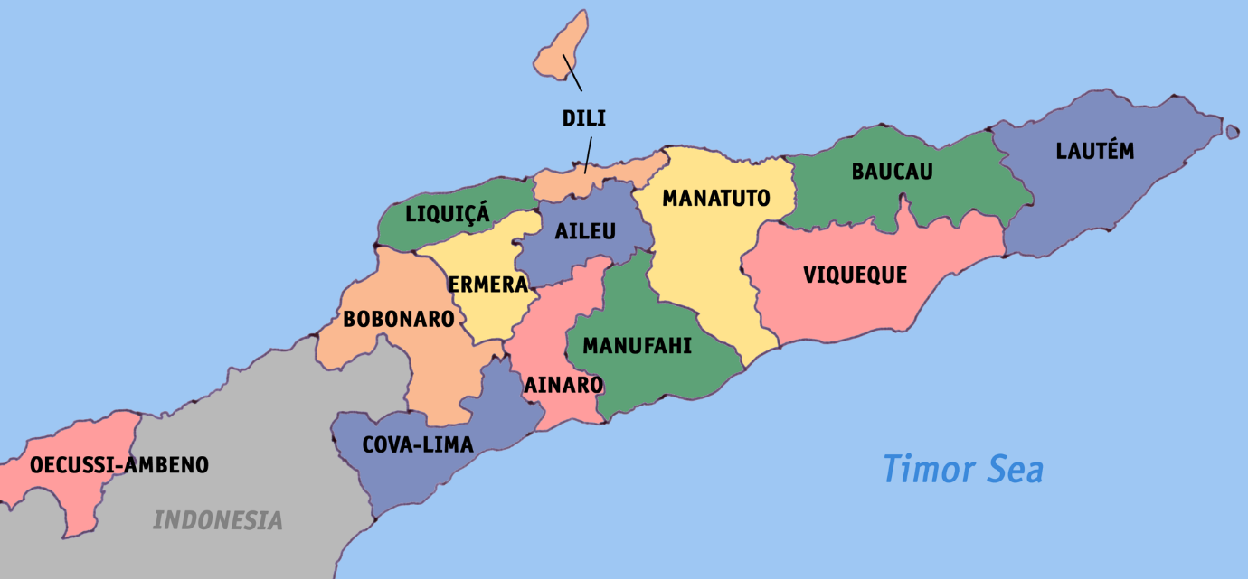
Timor-Leste also has an enclave called Oe-Cusse-Ambeno. It is officially called the Special Administrative Region of Oecusse-Ambeno (RAEOA), located on the north coast of West Timor, Indonesia. To the north of the capital Dili lies Atauro Island. The smallest Timorese Island is Jaco Island. It is an uninhabited island occupying the eastern end of Timor-Leste’s main island.
Image 2: Map of Timor-Leste
Image 3: Jaco Island
POLITICAL SYSTEM
Timor-Leste is a semi-presidential republic. The President is Head of State, who is elected by popular vote for a five-year term. The President guarantees respect for the Constitution and for State institutions and when necessary, can act to mediate conflicts. He can also veto legislation passed by the National Parliament.
Following legislative elections, the President appoints the leader of the party with plurality of seats, as Prime Minister. As Head of State, the President also presides over the Council of State, the Superior Council of Defence and Security, and is also the Supreme Commander of Armed Forces.
The unicameral Timorese Parliament comprises of members elected by popular vote to a five-year term. The number of seats can vary from a minimum of 52 to a maximum of 65. All registered political parties can run for legislative elections, and name their representatives to the National Parliament. The Prime-Minister is Head of Government.
CLIMATE
Timor-Leste has a hot tropical climate with a dry season from May-November, and a wet season from December-April. The temperature on the coast is usually between 25-35C, and in the mountains at higher elevations the weather is much cooler – sometimes wet and misty, and at other times clear and invigorating. There are many different micro-climates from dry barren hill sides to thickly forested peaks interspersed with cultivated areas. In general, especially during rainy season, the south countryside becomes much lusher and greener.
GEOGRAPHY
Timor-Leste is mountainous, with ridges of inactive volcanic mountains extending along the island. The south is slightly less mountainous, and has some plains near the coastline. Most rivers dry up at least partially during the dry season. Outside of some coastal areas and river valleys, the soil is shallow and prone to erosion. The easternmost area of Timor-Leste consists of the Paitchau Range and the Lake Ira Lalaro area, which contains the country’s first conservation area, the Nino Konis Santana National Park. It houses the last remaining tropical dry forested area within the country. It hosts a number of unique plant and animal species, and is sparsely populated. The northern coast is characterised by a number of coral reef systems that have been determined to be at risk.
There are around 41,000 terrestrial plant species in the country. Forests covered 35% of East Timor’s land in 2010. The forests of the northern coast, central uplands, and southern coast are distinct. Timor-Leste is home to the Timor and Wetar deciduous forests ecoregion.
Mountains in Timor-Leste
(elevation above sea level, in meters)
- Mount Ramelau – 2967
- Matebian – 2376
- Maubohilau – 2312
- Kablaki – 2062
- Datoi–Tapo – 1941
Image 6: Mount Ramelau
Rivers in Timor-Leste
Timor-Leste’s longest river is the North Laclo, at about 80 km (50 mi) long; its largest catchment is that of the Loes, which has a total area of 2,184 km2 (843 sq mi) (almost 15% of the whole country), about 9% of which lies in Indonesia.
Largest lakes (surface area, km2)
Lake Ira Lalaro is a freshwater lake in Mehara, of Lautém Municipality. It is the largest in the country. The lake is part of the Mount Paitchau Important Bird Area. The lake waters and that of Irasiquero River are a closed aquatic system. It covers between 10–55 square kilometres while the authigenic catchment basin covers 406 square kilometres.
Tasitolu (Portuguese: Tasitolu, Tetum: Tasitolu or Tasitolu, lit. transl. ’three waters’) is salty water and a protected area on the coast of around 8 kilometres west of the capital Dili. The Tasitolu wetlands include three saline lakes, an esplanade, and a beach; it has been designated a Wetland of National Significance. Tasitolu Peace Park was designated in 2002 because of its cultural and historical importance. The Tasitolu Important Bird Area accommodates several near-threatened species. It lies at an altitude of 0–403 metres above sea level, the 700 hectares (1,700 acres) protected area (whole area: 1,540 hectares (3,800 acres) consists of three permanent, shallow, saline lakes, and wetland surrounds. In some years, the water of the lakes turns red, probably due to red algae. There are several other small lakes in the country.
Compiled by:
Embassy of Malaysia
Dili, Timor-Leste


